B. THE BEGINNINGS OF SYRACUSE; FROM SALT POINT THROUGH THE VILLAGE OF SYRACUSE INTO A CITY
1. FIRST INHABITANTS & STRUCTURES
2. FIRST SCHOOLS|
3. FIRST CITY PARK
4. THE ERIE CANAL & THE DRAINING OF THE SWAMP
5. SYRACUSE HOUSE (HOTEL)
6. OTHER EARLY HOTELS
7. FIRST CEMETERY(S)
8. SYRACUSE GETS ITS NAME
9. SYRACUSE BECOMES A VILLAGE
10. RAILROADS COME TO SYRACUSE
11. 2ND COUNTY COURTHOUSE
12. FIRST STATE FAIR
13. CHURCH ST. DIASTER
14. TWO VILLAGES BECOME A CITY
15. MARKET HALL/CITY HALL
16. EARLY BUILDINGS
17. DRAWINGS
1. First Inhabitants and Structures
In 1780, what we today call Syracuse, was known as Salt Point. It was part of The Salt Springs Reservation and part of The Town of Manlius. Not long thereafter, in 1796, it wasrenamed Webster’s Landing after Ephraim Webster established a trading post just south of the inlet of Onondaga Creek into Onondaga Lake. At that time the area was little more than woods and swamps. In 1796 the area was commonly known as Salt Point.
The salt industry originated with The Iroquois, who were aware of the salt marshes, but believed it to be an evil spirit that made the water in the lake bad (which it did not). The Jesuits refined the process by boiling the brine into salt crystals. In 1788, New York State set up a reserve for the “common beneit for all.” ]
In 1797 The State took formal possession of the area and leased the land to salt producers. The industry flourished throughout The Civil War but started to diminish from the end of it. The last salt producer, Thomas K. Gale, closed in 1926.
The salt industry requires two major ingredients to be successful; timber to be used as fuel for the evaporation process and for pipes. and roads for delivering the product to market. James Geddes, a surveyor, created the necessary roads. As for the timber, 160,000 cords of wood were cut from that area that is now downtown Syracuse. This in turn cleared the land for construction and development. In 1800, Calvin Jackson built a log cabin, the first recorded residence of the area in the vicinity of Montgomery & East Genesee Streets. His son, Albion, was the first non-native person to be born here. By 1803, there were frame houses, a few log cabins, a post of ice, and a court. All of these were used by the 60 inhabitants of the area - all of whom were involved in the salt industry.
Geddes later surveyed 250 acres on the west side of Salina St. This area, today's downtown Syracuse was a dense forest and cedar swamps choked with underbrush, small pools of water, and knobs of hills. It was not a very attractive place to live in the early 1800s. However, Abram Walton bought the 250 acres in 1804 for $6,500 from New York State (the state used that money to build the Genesee Turnpike from Dewitt to Geddes, providing an east-west route for salt delivery, and competing with the Seneca Turnpike for travelers). This land became known as “The Walton Tract. By 1805 Walton’s Red Mill was built on Onondaga Creek, near (West) Genesee St. (that time known as “The Seneca Road” - the new state road), which was the center for community life. At first, it was a grain mill, and later, a sawmill, tannery, and tavern were added. But Walton soon realized that more was needed at the crossroads of The Genesee Turnpike and the trail going north to south to make the area attractive. He sold a half-acre plot to Henry Bogardus for $300 with the understanding that Bogardus would build a tavern there.
In 1807 the trail that passed by the tavern was surveyed to become a road, which became to be known as Salina St. At that time, it was but a swamp with sections of the road filled with logs and brush for horse footing. And even with this improvement, it was impassable a good portion of the year. So impassable that many times travelers would take their teams on routes further east, to avoid that inconvenience, on what is now Lodi St.
Bogardus completed the structure in 1808 (the predecessor of The Empire House). It was the first commercial structure to be built in the vicinity of what we now call Clinton Square, named after the first (and third) governor of New York State, at what is now the intersection of North Salina, East Genesee & James Streets (at that time known as Foot St.). It soon became a stopping place for stagecoaches and travelers riding between Albany and Buffalo and points north and south. At that time ithr intersection was known as “Bogardus Corners”. Prior to that it was called Salt Point (1780), then Websters Landing (1786). The settlement was later known as Milan, in 1809, and South Salina by 1812.
After a few years, the property was sold to Sterling Cossitt and the intersection became known as Cossit’s Corners, in 1814, and finally Corinth in 1817.
Much of the present-day downtown was a dreary waste of swamp that could only be traveled through with “corduroy” or “gridiron” roads.
Bogardus Corners. C. 1825 This is the earliest rendering of what is now downtown Syracuse
-West Genesee & North Salina Sts. The building on the corner is Williston’s Mansion House
with its extension on North Salina St., to the right. The larger building to the left is The
Marvin Block. The Empire House was later built on this site.
Joshua Forman left his home in the settlement of Onondaga Valley and opened a law
of ice in this new community. Unfortunately, the area was not highly regarded, being so
desolate that “it makes an owl weep to ly over it”.
In 1810, there were only 250 recorded residences there.
Ownership of the tavern continued to change hands many times over the years, but it
remained the center of community life. The Game of Bases, a predecessor of baseball, was
said to have been played there in 1819.
In 1823, O. H. Williston, then the owner of The Bogardus House, built a three-story wood
structure hotel facing Genesee St. and named it The Mansion House. The third
floor was kept largely open to accommodate large gatherings of all sorts -- lectures, religious and entertainment activities, and was called “The Hall for Public Occasions.”
Above is a hand-drawn map. Bogardus Tavern is A, B is Walton’s Red Mill, K the first
schoolhouse, the centerline going across is The Erie Canal. The diagonal line is Genesee St.
Abram Walton’s grist mill, on (West)Genesee St where it crosses Onondaga
Creek. It was commonly called “The Red Mill”, and was the center of community
life in the opening years of the 1800s.
The Red Mill stood until 1860 and was demolished to allow the stone bridge
that crosses West Genesee St to be built. The bridge is visible in this 1870 photo
and is still in use today.
An 1824 drawing of Clinton Square, looking west. The buildings are unidentified.
This 1831 map shows Walton’s “Red Mill “ on the east
side of Onondaga Creek on West Genesee St.
Walton needed to make his mills more efficient. The only technology available at the time
was water power, specifically the fast running water from a fall. To achieve this he dammed up a portion of Onondaga Creek and made a “run” in the area behind where The Armory Is now. The resulting reservoir was named Mill Pond. It remained in use until 1849 when it was filled in to eliminate a breeding ground for malaria-carrying mosquitoes. The fill came from the top of Prospect Hill, the future site of St. Joseph’s Hospital.
The approximate location of Abram Walton’s Red Mill on West Genesee St, just east of where it
crosses over Onondaga Creek.
This is the West Genesee St. bridge, where The Red Mill stood.
The map above, from 1834, shows Mill Pond at its largest when its full force was needed to operate both of Abram Walton’s saw and grist mills. The middle one from 1852 is after the filling in of the pond, in 1849, creating an area called Jefferson Park. The lower map, from 1860, is shortly after the 1st Armory was built.
A closer look at the 1834 map shows that the east-west streets, east of Mulberry (now
State) St., were given simple numeric names. South of the Erie Canal these were later
renamed, while north of the Canal they retained their numeric names to this day.
2. First Schools
A growing population required its youth to be educated; a schoolhouse was needed. The
first school in Syracuse was built in 1810, on the corner of South Clinton and Church St.
(later renamed Willow St.)
The first schoolhouse in The Village of Syracuse. Others that were added to
what is now The City of Syracuse were in Geddes in 1804 and Salina in 1805.
3. First City Park
The first city park was established in 1797 in what was then the Village of Salina. It is
where Washington Park is today. The area was still largely woods.
4. Erie Canal and The Draining of the Swamp
Joshua Forman started lobbying for a canal through this area as early as 1807. He
recognized that the salt industry would prosper greatly if cheap transportation was
available. James Geddes was appointed by New York State to conduct a canal survey to
determine which route would best serve the purpose. Several alternatives were
presented. Geddes favored the “inland” route and won the support of Dewitt Clinton, who
used his influence to secure his choice as a passage. The canal was built through Syracuse
between 1817 and 1820 and was completed and opened statewide in 1825. The original
canal was hailed as an engineering marvel — a 365-mile waterway with 56 locks,
constructed across New York State, that connected not only cities like Albany, Syracuse,
Rochester, and Buffalo but via the Great Lakes with faraway places like Chicago and
Detroit as well. It was first ridiculed as “Clinton’s Ditch,” because many doubted its
usefulness. But it soon proved its value when transportation costs were lowered by as
much as 95%. The Erie Canal not only enhanced the salt industry but contributed to the
development of Clinton Square and other nearby areas of Syracuse. It was soon realized,
even before it was finished, that the canal was not large enough to accommodate its traffic,
so an enlargement commenced in 1830, though the full extent of the upgrade was not
completed until 1863. The Erie Canal can also take credit for making New York City the
economic and
Financial success that made it the nation’s leading city and largest seaport.
Goods produced in New York State, to as far away as Midwest, were shipped to world
markets through the Port of New York via the Erie Canal. Over the years traffic and trade
increased so much that the canal had to be enlarged twice. It eventually was rerouted
away from the center of the cities it passed through to outlying areas and became known
as The Barge Canal, which is still in existence and used today. Those sections of the
original Erie Canal that were rerouted were abandoned in 1925. In Syracuse, this section
was paved over and became Erie Boulevard.
Locally the canal shifted the majority of the trade traffic from The Seneca Turnpike to
Clinton Square, which essentially became the “loading dock” for all of Syracuse. eventually
trade increased so that additional space was needed for mercantile outlets, leading to the
development of Hanover Square.

Governor Dewitt Clinton, the father of The Erie
Canal.
The digging of The Erie Canal through Syracuse was a nightmare. The sickness among the
workers from laboring in the swamps was horrific. To resolve this problem, and to make
the area suitable for future development, Joshua Forman and James Geddes in 1822
proposed draining the swampy area by lowering the level of Onondaga Lake. This was
accomplished by widening and deepening the little creek on the north end of Onondaga
Lake that connected the lake to the Seneca River. The work took two years to complete,
and it also assisted with the building of The Oswego Canal. Now not only was Syracuse a
more pleasant place to stay, but the area was also more conducive to the building of other
structures that could accommodate retail and commercial growth.
A drawing of West Water St. when The Erie Canal was finished, c. 1825
5. Syracuse Hotel/Syracuse House
With the completion of The Erie Canal, the demand for overnight lodgings increased.
Land was purchased from Joshua Forman on the southeast corner of East Genesee &
Salina Streets. and the construction of the “Syracuse Hotel” was completed in 1822. After
a few years, The Syracuse Co. purchased the property and rebuilt the structure renaming
it “The Syracuse House”. It was later enlarged again as demand for its rooms increased.
The original Syracuse Hotel in 1822. The stagecoach was still
the main means of overland passenger travel.
Once the Erie Canal was completed in 1825, the Syracuse House soon became the
foremost place for travelers to stay. The surrounding area became known as Clinton
Square. Commerce increased and spread and led to the creation of Hanover Square.
A postcard of the new Syracuse House in the early
days of the canal. Notice the small, probably wood
and residential, structures to the left of it. Salina St.
was still no more than a trail.
The Syracuse House when it occupied most of the east side of the 100 block of South Salina St.
6. Other Early Hotels
OLD LINE HOUSE On the northwest corner of South Salina, Harrison & West Onondaga Sts. Built in 1836 and demolished in 1865 for the construction of The Cook Block. The Mowery Hotel was built just south of it.
DROVER’S HOME, A/K/A EAGLE TAVERN The Eagle Tavern was at the intersection of West Genesee & Yellow Sts. It was built shortly after Bogardus Tavern at the corner of West Genesee & North Salina Sts. The hotel portion of the building was known as Drover’s Home. The structure burned down in 1842.
EXCHANGE HOTEL Built in 1831, it was on the northeast corner of South Salina & East Washington Streets. Within the hotel was Library Hall, which was used for ublic meetings and entertainment. Twenty years later the corner proved to be too valuable to remain a hotel, and its purpose turned to retail. The first McCarthy building was built on this site.
ALHAMBRA/TREMONT/SHERMAN HOUSE Built on the corner of East Washington and South Warren Sts. in 1846 by Samuel Larned, it was in competition with the other hotels and restaurants in Vanderbilt Square. The building burned down in 1868 and The Larned Building was built in its place.
BRINTNALL TAVERN/CANDEE HOUSE- Hiram Brintnall purchased a home on the northeast corner of East Fayette & South Warren Sts., c. 1834, and rebuilt it and added to the structure to make it a hotel.
7. First Cemetery(s)
The first cemetery in The Village of Syracuse was established in the early 1800s, located
on the southwest corner of West Water & South Franklin Sts. It did not take long for it to
ill up, and its presence hampered urban development. The Village found another location
to the east on Lodi St. This became Rose Hill Cemetery. About 15-20 bodies from the old
cemetery were never disinterred and moved. Before very long the same issues arose with
Rose Hill, and the City bought land to the south to create Oakwood Cemetery, in 1859.

The words” Burying Grounds” can be seen on the left in this 1831 map.
The southwest corner of West Water & North Franklin Streets, the site of Syracuse’s
first cemetery. Not all the bodies were disinterred when Rose Hill opened on Lodi St.
Some wonder if this parking lot is haunted.
Another early cemetery was Old Rose Cemetery on what is now Jamesville Ave, near the
corner of East Colvin St. It was a burial ground for the Scottish who had settled in the area. Some 60 people are buried there. It was in use from 1844-1904. It has long since been abandoned and is heavily overgrown.
a. Scottish Cemetery
8. Syracuse Gets Its Name
It was time to find a proper name for the area; Bogardus Corners, Salt Point, or Cossitt
Corners no longer seemed appropriate. Joshua Forman suggested that the name
commonly used, “Corinth,” become permanent. But since Corinth already existed in New
York State, another name had to be found. John Wilkinson, who was the first established
lawyer in Syracuse, in 1819, and was scheduled to be the area’s first postmaster,
suggested “Syracuse” because of a poem he had read that bore a resemblance to the
Sicilian city of that name (“Siracusa,” in Italian). The poem included a description of a salt
spring! Everyone seemed to be happy with the choice, so in 1824 the name was formally
adopted.
Judge Joshua Forman-The Father of Syracuse
John Wilkinson- the name creator of Syracuse
9. Syracuse Becomes a Village
The building of The Erie Canal, and the draining of the swamp around it, were the critical
elements for the development of Syracuse. It was now a fast-growing area and was
incorporated as a village in 1825, with Joshua Forman named as the first Village President.
Syracuse became the county seat in 1827. The canal passed through the heart of
Syracuse, splitting Clinton Square and the area into two competing villages, however. It
also spurred the area’s growth.
Syracuse started out as a cluster of log cabins, then clapboard structures and frame houses, stables, blacksmiths and sundry stores. Eventually, brick homes and structures
were built.
In 1824 a group of Albany businessmen purchased what remained in the old Walton
Tract, which is what is now largely downtown Syracuse, from its current owner for
$30,000. The Syracuse Company was formed and lots were sold from that. Some of the
principals of the company had names that we are familiar with today; James, McBride,
Townsend, Hawley, and Burnet.
In 1825 the Marquis de Lafayette visited Syracuse. He was escorted down from Onondaga
Hollow and was greeted by Village President Judge Forman and a large group of citizens.
In 1832 a cholera epidemic swept through Syracuse, which took the lives of over 100
inhabitants. Many more were to be stricken with the disease and its effects as it lingered
on for two years into 1834.
An 1834 map of The Village of Syracuse
10. Railroad Comes to Syracuse
It was not long after the canal system was in place when modern technology began to
surpass it. A horse-drawn railroad between Onondaga Lake and Syracuse, and from
Syracuse to Onondaga Hollow, was planned in 1829. New technology (steam) was
addressed with a statewide convention held at The Syracuse House in 1831. A resolution
was passed calling for a railroad to be built from Schenectady to Buffalo. In 1834 the
Syracuse-Auburn Railroad was incorporated and, two years after that, the Syracuse-Utica
Railroad. But the tracks were yet to come.
The Auburn-Syracuse Railroad
irst passed through Syracuse in 1838, with horse-drawn cars, and without a specific drop-off location. A platform would eventually be built where the line ended at West Genesee St. In 1839, the first steam-powered locomotive passed through Central New York. Then came the Syracuse & Utica line in 1839, the Syracuse & Auburn line in 1841, and the Syracuse & Oswego line in 1848. Immediately, rail became the favored means of long-distance passenger travel, freight, and mail, while the canal was relegated to bulk cargo. Railroad traffic increased to a point where an adequate station was needed. Attempts were made to build a station in The Mill Pond area. But that would require trestles to be built over it, which proved to be too difficult.
11. 2nd County House
As Onondaga County and The Village of Syracuse grew and became an important center
for commerce, trade, and transportation, it was decided to move and create a new 2nd
County Courthouse closer to the center of the county. In May of 1830, the 2nd County
Courthouse on North Salina St. and Ash St was opened, with its jail directly behind it. The
Village of Syracuse had a population of approximately 2,500 at the time.

Notice the broken line at Division St. This was the borderline between The Village of
Salina to the north and The Village of Syracuse to the south. When the two merged to
create The City of Syracuse, in 1848, this border was eliminated. However, the area to
the north was honored with being named The First Ward.
This is believed to be the only known photograph of The 2nd County Courthouse, It
must have been taken from the west side of North Salina St. on Ash St. The building in
the distance to the right was the county jail. George Barnard, the famed Civil War
photographer, took this photo in 1854.
The building burned down on February 5, 1856. Ironically, there was talk about replacing
this courthouse with a new one prior to the fire. In the short period of time since it the
2ndcourthouse had opened, the population of Syracuse had grown more than ten-fold, to
26,000. Syracuse was now a booming, vibrant city with a thriving economy, with salt
production being the main driver of its success. This growth put increasing demands upon
the county’s judicial system, to the point where the need for a new and larger courthouse
was needed.
This building is on the corner of North Salina & Ash Sts. was built
on the site of The 2nd County Courthouse in 1860.
The jail was a separate building from the 2nd Court House. It was also a gallows. On November 19, 1840, Zachariah Freeman Jr. became the first person to be executed in Onondaga County. The building remained in use until 1850 when the county built a new penitentiary on the site that was later to become North High School.
12. First State Fair
By the 1840s, Syracuse was an upcoming community of 11,000. In spite of the fact that it
was notorious for having poor roads, the canal and the railroad made it a convenient and
easy place to get to. In 1841 it was the logical choice for the location of the first New York
State Fair. This was set up in the area that is now bordered by North Salina, Division, Ash,
and Townsend Streets., on the grounds where the 2nd County Courthouse was.
For 50 years the State Fair was held in different locations throughout the state. It returned to Syracuse, now a city, in 1849. This time it was located on James St. Hill, near the present-day Highland St. Vice President Millard Fillmore, and the ever-popular Henry Clay, attended the event that year. The first-ever Ferris Wheel was erected for the fair, a 50-foot tall structure.
It was not until 1890 that Syracuse (technically, the Town of Geddes) became the permanent home of The New York State Fair.

13. Church St. Disaster
In 1841, Charles Going owned a two-story wood-frame warehouse near Church St. (now
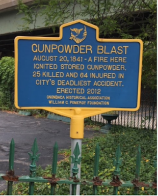
Willow St.) on the west side of The Oswego Canal. He was a lumber merchant and basically used it for the storage of his product. On August 20 of that year, a fire broke out inside the building. At first, it seemed like a modest one and was quickly brought under control. Then panic broke out. It was discovered that gunpowder was being (illegally) stored there. Unfortunately, not everyone heeded the warning. Within a few seconds, there was a great flash explosion, which shook the ground so hard that it could be felt as far away as Fulton. Some even thought that there had been an earthquake. Many of the spectators were blown into the canal and many more were covered with debris. Once the flames burned out and the smoke cleared the disastrous results became apparent: 64 horribly injured and 25 dead, among them six firemen. This was the most horrific disaster in Syracuse’s (village and city) history thus far, with much loss of life. It was ascertained that there were 625 lbs of powder in 27 kegs.
This marker was placed at the location of the explosion on the north side of the
100 block of East Willow (formerly Church) St, in front of the parking lot next to
Collelas’s Antiques ( the former Howard & Jennings Pump Manufacturer).
14. Two Villages Becomes a City
While the villages of Salina and Syracuse were both growing, as a result of the canal and
railroad, Syracuse was growing more rapidly because of its proximity to them. The
bitterness between the citizens of the two villages grew so intense that a riot between
them ensued on New Year’s Day 1846. It was known as “The Cook Coffee House Riot”. The
fathers of both villages had had enough of this type of activity and decided to initiate the
merger of the two villages into one metropolitan area. In 1847, the State Legislature
approved the Syracuse City Charter and, in 1848, the voters of the villages of Salina and
Syracuse both agreed to merge and become a city, named Syracuse. Harvey Baldwin was
elected as the city’s first mayor.

Cook’s Coffee house was located on the corner of East Washington St and South
Warren St., where The Vanderbilt House and later The First Trust Bank were built (see
the section on Vanderbilt Square).
15. Market Hall/City Hall
When the Syracuse section of The Erie Canal was completed, in 1820, a basin was needed as a parking lot and turn-about for the barges and packet boats. This Was located where the present City Hall is. The stagnant water soon became a health hazard, so it was filled in 1842. In 1845, a building was built on the site to serve market purposes on the first floor and municipal services on the second. When Syracuse became a city in 1848, the city government moved in and the building was renamed City Hall. It remained here until 1892.
A tower was added to the building in 1857, and a bell was installed the following year. It was
rung for public occasions, both happy and sad, but it mostly functioned as a fire alarm for the
volunteer firemen. The city paid $1 for each alarm that sounded to whoever reported it. As a
result, many false alarms occurred!


Harvey Baldwin, the first mayor of Syracuse, was
elected after the merger of the Villages of Syracuse
and Salina.
Harvey Baldwin is interred in his family tomb at Rose Hill Cemetery, on the
Highland St. side. Thousands of motorists pass it every day on busy Lodi St., not
knowing what it is. Rose Hill predates Oakwood as a burial ground.
A bird's eye view of Syracuse c. 1850.
A lithograph of Salina St, looking south, from The Ballou Companion of 1852, The Syracuse
House, the 1st Presbyterian Church, and the 1st NYCRR station are recognizable images.
An 1861 drawing of Clinton Square, looking north from the bridge that crossed The Erie
Canal. The Syracuse House is to the right, the Voorhes Hotel is in the center (later to become
The Empire House). The recently completed 3rd County Courthouse is to the left of it and the
1st Wieting Block is on the left side of the drawing.
This lithograph features a locomotive passing through Market
Square on East Washington St.
Not far from Clinton Square,1860. The Greenway Brewery is in
the background.
16. Some Early Building
56-60 South Salina St.
An early tenant of 24 East Genesee St.
The photo in the bottom left is from the 1850’s labels this building as 45 East
Genesee St. It does not match up with any of the buildings past or present on
this side of the street. Perhaps it stood at 120 East Genesee St. prior to the Bank
of Syracuse Building and preceded The Franklin Building.
17. 1868 Drawings of Syracuse
The north side of Clinton Square.
The Syracuse House and the 100 block of East Water St.- looking southeast.
South Salina St. & East Fayette St. looking north
The Empire Block on North Salina St-looking west.
South Salina St at East Fayette St-looking north
An 1868 birds eye view of the young city of Syracuse.
This photo of Syracuse from 1870 looking south.


Comments
Post a Comment